Back in October, I argued that Congress needed to step in and update the underlying laws that govern American remote sensing policy. I acknowledged NOAA’s effort to update the regulations for satellite imagery, but I was skeptical that it would have an impact.
In 2020, the Department of Commerce revised its regulatory regime for remote sensing systems. The revisions sound helpful on paper, but a year later, there is no higher-quality data on the market and I have not seen any near-term plans to collect it.
I missed something huge. The week before the post went live, and while I was writing it, Albedo received approval from NOAA to collect 10-centimeter resolution imagery. This is great news and was a big miss by me.
Simulated Imagery
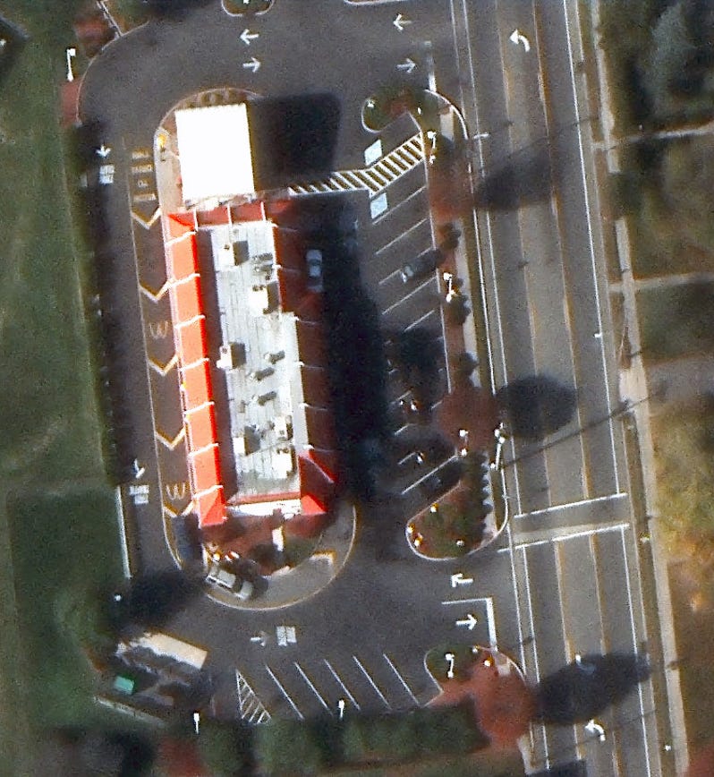
Earlier this month, Albedo dropped a strip of simulated imagery. From their description and my experience with this type of data, my best guess is this is aerial imagery that was processed to the correct specifications. No matter how this dataset was created, the results are striking.
My jaw dropped when I zoomed in on the images. I know that sounds weird because this looks like what you might find on Google Maps. In the US, we are blessed with regular aerial imagery flights. That is not the case elsewhere in the world. I have only seen pictures like this taken from airplanes. Access to this is going to change lives in low- and middle-income countries.
Shifting the perception floor
If this sounds expensive, then you are correct. The thing is, there are huge upsides to increasing the quality of satellite imagery. Every piece of imagery has a perception floor or the smallest object that you can reliably see.1 In the picture of the McDonalds, a $100 bill sitting in the parking lot is below the perception floor, but the number of air conditioning units on the roof is above it.
One of the things that the shift in the perception floor changes is around cars. Firms use 30 cm imagery to count the number of cars in parking lots to try to predict if a company met its quarterly earnings targets. This is good, but 10 cm imagery changes the perception floor from “how many cars are here” to “how many cars of a make and model are in a parking lot”.
The image above shows a parking lot with 8 cars in it. Most of them appear to be sedans, but there is a white ban in the parking lot. The next frontier is for a computer vision start-up to partner with Albedo to create a training dataset of cars for training AI. The company that can pick out Teslas and Ford F-350s first will have a big leg up.
Other use cases
Investor Garry Tan and Albedo CEO Topher Haddad’s conversation outlines a number of additional use cases for this data.
A word of caution
This is what the imagery is supposed to look like, but Albedo has yet to launch a satellite into space. The permission from NOAA itself might be enough to spur a big-dollar acquisition from Maxar or Planet. Launching things into space is expensive and Albedo might not be able to gather enough venture capital money to make it happen. This is especially true if a satellite or two meets its demise before it gets to space. Tech policy practitioners and geographers should not use this to prematurely declare victory. There is still work to be done.
Maps Lie to You
On Tuesday, April 12 from 20:00 to 23:00 (Copenhagen time)2 I am leading an Interintellect salon about how maps are not as truthful as we oftentimes believe and how that trust is weaponized. The discussion with start from two chapters of How to Lie With Maps: War and Propaganda. I think it will be a fun evening of deconstructing what we know about maps and trying to cope with our cognitive biases. Tickets are 10 USD (68 DKK; 9 Euro).
Interintellect salons are a special type of discussion forum where experts and laypeople can discuss important issues together in a safe environment. If you have never heard of the Interintellect salon, check out their Five Rules of Gathering. I am a long-time salon attender, but a first-time host.
I made up this term. There is probably a technical one, but I don’t know it. I have never claimed to be an imagery specialist.
11:00-14:00 (San Francisco); 14:00-17:00 (New York City); 18:00-21:00 (UTC); 23:30-02:30 (Mumbi); 02:00-05:00 (Singapore)


