


Google is not Kneecapping Google Maps to Force More Engagement
Also, Danish Political Parties, L-P Papers, and Dune

I am testing out something new. Substack just rolled out what those of us that remember LiveJournal would call “The Cut”. Everything before the cut is accessible to everyone and can be sent to your whole email list. Everything after is visible only to paid subscribers. I think this presents an opportunity for the A-story to be free and the B-stories to be for paid subscribers. A win-win. If this works and I don't get complaints, this might be the format going forward.
Where the streets have no name
This post has been making the rounds on Twitter. I have no idea if it is true or a shitpost; I haven’t sifted through the mountain of leaked internal Google documents. It has also hit a nerve, so people believe that it is true. The narrative is that Google is forcing people to engage with their product more making Google more money. The problem is that narrative is a lie.

Dynamic labeling
The process that this tweet talks about is called dynamic labeling. It is an industry-standard and for a good reason. Here is Washington, DC with the entire Capital Beltway (Interstate 495) in zoom. You can see that Interstates, US Routes, and some State Routes are visible.

Which state routes are chosen are a type of special sauce that differs from mapping provider to mapping provider. My best guess is that it has something to do with the number of lanes that the road has, if it is controlled access or not, and how many trips Google has recorded on that road. It isn’t crazy to think that states may have some input into the roads that are labeled, MD-200 is tolled, but nothing looks too weird.
When you zoom in to an area, you see the names of the major streets, but none of the alleyways or smaller streets. Take this screengrab of Capital Hill and H-Street. You see the numbered, lettered, and state-named streets. Plus Independence Ave and East Capital St.
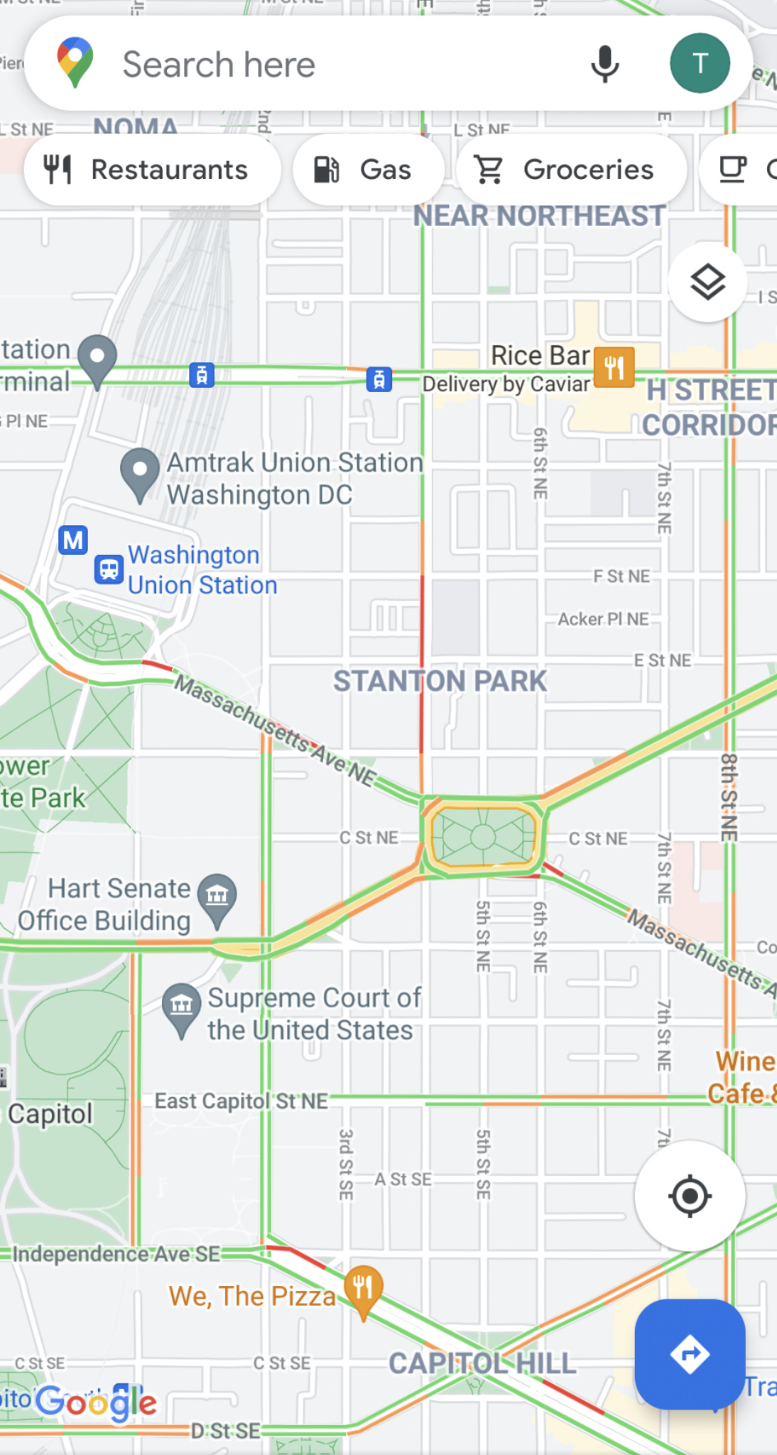
If we would zoom further in, the smaller streets would get labeled. This is dynamic labeling doing its job.
Industry Standard
The thing is that every digital map does this. As I talked about in my previous defense of Google Maps, the problem that every new map maker makes is adding too much detail to their map. Too many details, such as street names, make it hard for users to get what they want from a mapping app. Take MapQuest, a company that 100% rolls its own map tiles without any Google data. At a city-wide zoom, they show fewer labels than Google.

This is also true at the neighborhood-sized zoom. Google has more labels than MapQuest does.

MapQuest is only one producer of map tiles. Mapbox is the new startup in this space. Surely they are doing something different with their cartography. But, when you take a look at their standard streets base map, the answer is no. They make almost all of the same cartographic decisions as Google Maps and MapQuest.


Not a paper map
Digital maps are not paper maps. When you try to force every digital map to be the detail of a USGS quarter quadrangle you end up with a mess. Consumers need to let digital maps do what they do best: showing the most relevant details.
This is not to say that everything about Google Maps is great. I do not like the way that they use to show waypoints at a zoom level. For example, We The Pizza probably spent large quantities of money to be one of two restaurants shown at that zoom level. But, MapQuest showing nothing, not even the Metro station, is not good either. There is probably a good middle ground between the current Google Maps and a map app that can’t show any waypoints except ones directly asked for. I just don’t know where that line is.