This is a continuation of my map-related thoughts on the Russo-Ukrainian War. You might want to check out Maps and Ethics: Ukraine which discusses how Ukraine should be depicted in map products and how open-source satellite imagery is used.
A week ago, Russia turned its saber-rattling into action and invaded Ukraine. Contrary to the pre-invasion reports from western intelligence agencies, Kyiv did not “[fall] in just a few days”. Instead, the country dug in to resist the invasion. Ukraine’s billionaire former president (who is under indictment for treason) joined the territorial defense force instead of fleeing to safety. Volodymyr Zelenskyy turned down the US’s offer to extract him from the country and is still posting videos from Kyiv. It is impressive to watch. This situation has spawned another tranche of thoughts.
Just say no to theater-level maps
I fully understand it. The situation in Ukraine is changing rapidly, and I, like most people, find comfort in plotting it on a map. Several groups have moved in to fill the gap. A group of OSInt Twitter accounts has a series of maps, as does the International Institute for the Study of War, and Wikipedia. The problem is that these maps are a gross oversimplification of the situation and give certainty where there is little.
One of the ways that they do this is by showing the world as a Paradox Interactive video game. I love Europa Universalis IV.1 Here is my most recent playthrough as Brandenburg-Prussia. The problem is that the view of war that is promoted — areas are under the control of whichever army last moved through the area — is disconnected from modern warfare. We are starting to see signs of gorilla warfare being carried out by Ukrainian citizens behind Russian lines. Russia has still not been able to gain air superiority which allows Ukrainian planes and drones to attack. It is hard to argue with a straight face that Russia controls much of the “newly won” territory in a meaningful way.
Instead, we should be plotting where battles are currently happening. From that, if viewers want to draw battle lines in their minds, they can. But in the middle of the fog of war, it does not make sense for people in London and Washington, DC to be plotting zones of control. I would rather people wait a few weeks or months to make maps like this when the situation on the ground is less fluid.
If plotting the ongoing battles is not helpful enough, it might make sense to show arrows for troop movements. Think of the battle maps from a history textbook. That would show movement without having to dive into the messy question of who has control over what in an uncertain situation.
Google Maps the super spy
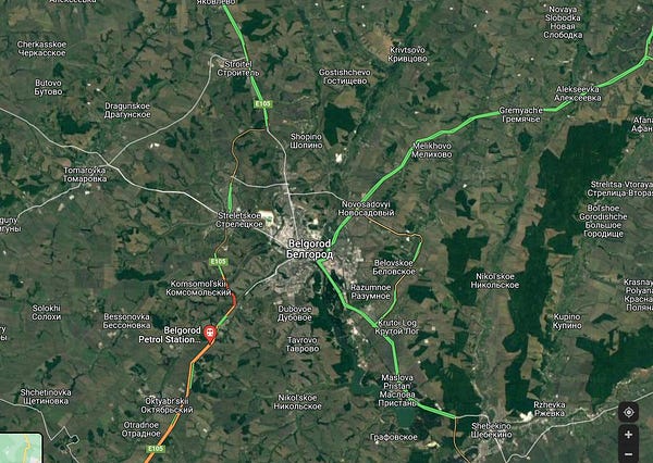
The ongoing war has revealed the power of the smartphone in new and interesting ways. One of the weirdest side effects of people having a GPS on them wherever they go and not being able to navigate without it is that Google Maps receives a ton of data. Since tanks and armored personnel carriers move slower than cars, Google Maps sees it as a traffic jam and marks the road. On the day of the invasion, it was possible to watch the advance into Ukraine by watching the red line move. It was extraordinary.


If you are in a warzone, it is probably for the best that you turn GPS off. Nobody knows who else has access to the information either through data sharing or data theft.
The 1980s are back
Since this was published, I have had more discussions with friends about how a potential Russian first strike of the United States might look. There is a decent argument that political centers might be spared in an attempt to have someone to negotiate with post-nuking. My current thoughts do not fully align with this, but it is left as-is.
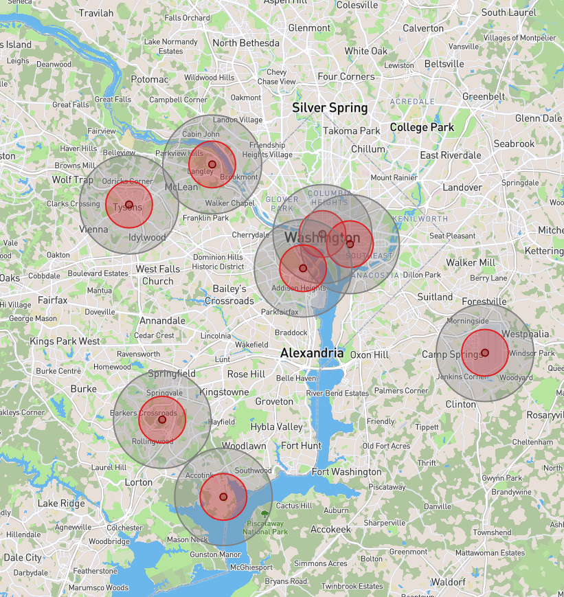
Putin’s threat of nuclear war if the US steps into Ukraine has ignited fears that were put on the shelf when the cold war ended. I have seen people in DC plot out an airburst in central DC on Nukemap and claim that they are good. The problem is that there is no indication that we would have a limited nuclear war due to the threat of second-strike capabilities. It would make sense that in a first-strike scenario, they would target American command and control. Additionally, a saturation bombing strategy would allow for a percentage of ICBMs to fail or get intercepted without jeopardizing leaving a high-value target standing.
Above, is a map of where I would guess the Russians would target anti-bunker groundbursts. (Dark red: bunkers are gone; light red: cement buildings are gone; gray: wood frame buildings are gone.) The locations chosen are a mixture of communications hubs, military installations, intelligence agencies, the White House, and the Capitol Building. Under this scenario, the destruction of the DMV would be widespread and intense. Nuclear war is nothing to laugh about.
It might have been what has eaten up my time last month


