


Maryland 2020 Redistricting
Three tries at a fair map

It is the best and worst time of the decade for anyone who works at the intersection of politics and geography: redistricting. It is great because it is an unlimited well of content. The problem is that most states with a political redistricting process, like Maryland, are going to gerrymander their districts to help whoever has the supermajority in the statehouse. The states with a less political method of drawing districts have started to release theirs.
To get my prediction out of the way, I think that Maryland is going to return an 8 D - 0 R map (like the one Dave Wasserman shows below) because Andy Harris, the congressman from Maryland’s First Congressional District, makes enough members of the House of Delegates rather unhappy. This is not unfounded, Harris is a dangerous kook who cynically decided to go all-in on Trump after being a pseudo-libertarian stopped paying him dividends.1


Politicians from Baltimore and the DC Suburbs feel that it is their right to effectively disenfranchise voters in Western Maryland and the Eastern Shore because Texas cuts Travis County to strips to benefit the Republicans. This is wrong, but the Supreme Court basically affirmed that there is no federal remedy for doing this. So, the practice continues.
The 2020 census data provides four facts for any district maker.
Baltimore City is now too small to support a district on its own (585,708 v. 772,153 for a district)
The 9 counties of the Eastern Shore are also too small for a district on their own as well (456,810 v. 772,153)
You can be contiguous and cross the Chesapeake Bay at any point
Montgomery, Prince George’s, and Baltimore Counties are too big and must be split at some point.
With reality and the insights from the 2020 census out of the way, what would a fair 2020 map look like? In 2020, Joe Biden got ~65% of the vote in Maryland. If the districts matched that result they would be roughly 5 Democratic, 1 swing, and 2 Republican. Maryland is roughly 50% white, 30% Black, 10% Hispanic, and 10% of other races or ancestry. So, half of the districts should be majority white and half should be majority-minority. Districts should both be compact and split counties as rarely as possible.
Attempt 1
My first attempt at a more fair map can be found below and on Districtr. MD-1 does not hit the Mason-Dixon Line, which is dominated by MD-8. I think this map has no VRA problems. Baltimore City is unbroken and all of the majority-Black parts of Prince George’s County is found in a single district.
To make MD-1, I merged the Eastern Shore with Southern Maryland. MD-2 is the northern and eastern suburbs of Baltimore. MD-3 is Baltimore City and a strip of the suburbs. MD-4 is in the suburbs of both Baltimore and DC. MD-5 is in the suburbs of DC in Montgomery County. MD-6 is Anne Arundel County and parts of Prince George’s County. MD-7 is in the suburbs of DC in Prince George’s County. MD-8 is made up of Western Maryland, Carroll County, and the northern parts of Baltimore and Harford Counties.

Racial breakdown:
Majority Black: 3 and 7
Majority minority: 4 and 5
Majority white: 1, 2, 6, and 8
Probable party breakdown:
Democratic: 3, 4, 5, 6, and 7
Swing: 2
Republican: 1 and 8
I hit my goal of an even split between majority white and majority-minority districts.
Attempt 2
My second attempt at a more fair map can be found below and on Districtr. This try has MD-1 and MD-8 splitting the Mason-Dixon Line. Baltimore City is split east and west between MD-2 and MD-3. One of the chief problems is that this is most likely a VRA problem due to how majority-Black Baltimore City is divided to be merged into the white suburbs.
MD-1 is made up of the Eastern Shore, northern Harford and Baltimore Counties, and Carroll County. To make MD-2 it is half of Baltimore City and parts of Baltimore and Harford Counties. MD-3 is the other half of Baltimore City and parts of Baltimore County. MD-4 is a sliver of Baltimore County, Anne Arundel, and Calvert Counties, and the southern part of St. Mary’s County. MD-5 is comprised of parts of Montgomery, Prince George’s, and Howard County. MD-7 is parts of Prince George’s and St. Mary’s Counties and all of Charles County. MD-8 is Western Maryland, Frederick County, and parts of Mongomery and Howard County.

Racial breakdown:
Majority Black: 7
Majority minority: 3, 5, and 6
Majority white: 1, 2, 4, and 8
Probable party breakdown:
Democratic: 2, 3, 5, 6, and 7
Swing: 4, 8
Republican: 1
I accidentally made two swing districts instead of two republican ones.
Attempt 3
After discussing this issue on Facebook a bit, Dan Smith, a friend from college, sent me a map that he has been working on. Dan is an aide for a Republican member of the House of Delegates and has worked for the Maryland GOP in the past. I was extremely interested to see what he came up with. I used the shapefiles that he sent me to recreate it in Districtr. My version does not perfectly match his, MD-3 is a tad too small. But this should be enough to get a picture of what he was thinking of.
The most pronounced thing about this map is that MD-6 is the district rooted in Western Maryland instead of MD-8. Dan also uses MD-7 as a district for Baltimore City and parts of Baltimore County instead of MD-3 like I would have. The most interesting district on this map is MD-3. It occupies the zone between Baltimore and Washington DC.
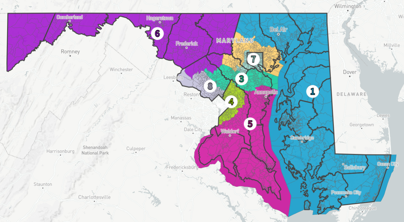
Racial breakdown:
Majority Black: 4, 7
Majority minority: 8
Majority white: 1, 2, 3, 5, 6
Probable party breakdown:
Democratic: 2, 3, 4, 5, 7, 8
Swing: None
Republican: 1, 6
My worry with Dan’s map is how many white-majority districts there are. MD-8 is majority-minority, but only by a hair. Also, the lack of any swing districts. There is some irony that a Republican operative’s map is less kind to the Republican party than mine.2
On Tuesday, I put out an out-of-cycle post about why you, as an individual, should probably not take Ivermectin. Due to some technical difficulties, the post was sent to subscribers, unlocked, and then a follow-up post was sent to everyone informing them of the unlocked post. If you missed it through all of the madness, it can be found below.

Harris’s presumed Democratic replacement in an 8 D - 0 R world, Heather Mizeur, is something of a carpetbagger to the Eastern Shore who “retired from politics” to Kent County from Takoma Park a few years ago to operate an organic herb farm after she crashed and burned in the 2014 primary for Governor. The idea that she is running right after redistricting because Harris’s votes on January 6th is complete hogwash. My gut feeling is that she was promised that MD-1 was going to be redrawn to be friendly by one of her former colleagues in the House of Delegates.
Some of this might be from my imperfect attempt to xerox his districts.